History of the Maya civilization
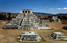
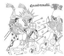
[2] Modern scholars regard these periods as arbitrary divisions of chronology of the Maya civilization, rather than indicative of cultural evolution or decadence.[10] Settlements were established around 1800 BC in the Soconusco region of the Pacific coast, and they were already cultivating the staple crops of the Maya diet, including maize, beans, squash, and chili pepper.[16] By approximately 400 BC, near the end of the Middle Preclassic period, early Maya rulers were raising stelae that celebrated their achievements and validated their right to rule.[18] In the Late Preclassic Period, the enormous city of El Mirador grew to cover approximately 16 square kilometres (6.2 sq mi).[22] Kaminaljuyu was situated at a crossroads and controlled the trade routes westwards to the Gulf coast, north into the highlands, and along the Pacific coastal plain to the Isthmus of Tehuantepec and El Salvador.[28] This period marked the peak of large-scale construction and urbanism, the recording of monumental inscriptions, and demonstrated significant intellectual and artistic development, particularly in the southern lowland regions.[56] At this time, the use of hieroglyphic script on monuments became widespread, and left a large body of information including dated dynastic records, alliances, and other interactions between Maya polities.[66] During the 9th century AD, the central Maya region suffered major political collapse, marked by the abandonment of cities, the ending of dynasties and a northward shift in activity.[68] There is evidence that the Maya population exceeded the carrying capacity of the environment, resulting in depleted agricultural resources, deforestation, and overhunting of megafauna.[79] Chichen Itza rose to prominence in the north in the 8th century AD, coincident with the abandonments occurring in the south, which underlines the economic and political factors involved in the collapse.[83] This was symptomatic of changes that were sweeping across the highlands and neighbouring Pacific coast, with long-occupied cities in exposed locations relocated, apparently due to a proliferation of warfare.Cities came to occupy more-easily defended hilltop locations surrounded by deep ravines, with ditch-and-wall defences sometimes supplementing the protection provided by the natural terrain.[83] Walled defences have been identified at a number of sites in the north, including Chacchob, Chichen Itza, Cuca, Ek Balam, Mayapan, Muna, Tulum, Uxmal, and Yaxuna.[81] During the Late Postclassic, the Yucatán Peninsula was divided into a number of independent provinces that shared a common culture but varied in their internal sociopolitical organisation.[87] At the time of Spanish contact, polities in the northern Yucatán peninsula included Mani, Cehpech, Chakan, Ah Kin Chel, Cupul, Chikinchel, Ecab, Uaymil, Chetumal, Cochuah, Tases, Hocaba, Sotuta, Chanputun (modern Champotón), and Acalan.[88] A number of polities and groups inhabited the southern portion of the peninsula incorporating the Petén Basin, Belize, and surrounding areas,[89] including the Kejache, the Itza,[90] the Kowoj,[91] the Yalain,[92] the Chinamita, the Icaiche, the Manche Chʼol, and the Mopan.[94] In the centuries preceding the arrival of the Spanish, the Kʼicheʼ had carved out a small empire covering a large part of the western Guatemalan Highlands and the neighbouring Pacific coastal plain.[100] After the Aztec capital Tenochtitlan fell to the Spanish in 1521, Hernán Cortés despatched Pedro de Alvarado to Guatemala with 180 cavalry, 300 infantry, 4 cannons, and thousands of allied warriors from central Mexico;[101] they arrived in Soconusco in 1523.[108] In 1697, Martín de Ursúa launched an assault upon the Itza capital Nojpetén and the last remaining independent Maya city fell to the Spanish.At times the colonial administration encouraged the traditional economy in order to extract tribute in the form of ceramics or cotton textiles, although these were usually made to European specifications.[111] The 260-day tzolkʼin ritual calendar continues in use in modern Maya communities in the highlands of Guatemala and Chiapas,[112] and millions of Mayan-language speakers inhabit the territory in which their ancestors developed their civilization.[116] In 1839 American traveller and writer John Lloyd Stephens, familiar with earlier Spanish investigations, set out to visit Uxmal, Copán, Palenque, and other sites with English architect and draftsman Frederick Catherwood.[114] Their account was picked up by 19th century antiquarians such as Augustus Le Plongeon and Désiré Charnay, who attributed the ruins to Old World civilizations, or sunken continents.[119] The final two decades of the 19th century saw the birth of modern scientific archaeology in the Maya region, with the meticulous work of Alfred Maudslay and Teoberto Maler.Due to their limestone construction, the monuments affected the chemical makeup of the soil as they deteriorated; some moisture-loving plants are entirely absent, while others were killed off or discoloured.[129] Detailed settlement surveys of Maya cities revealed the evidence of large populations, putting an end to the vacant ceremonial centre model.[131][132] The capital of Sak Tz’i’ (an Ancient Maya kingdom) now named Lacanja Tzeltal, was revealed by researchers led by associate anthropology professor Charles Golden and bioarchaeologist Andrew Scherer in the Chiapas in the backyard of a Mexican farmer in 2020.


Maya civilizationPeopleSocietyLanguagesWritingReligionMythologySacrificeCitiesArchitectureAstronomyCalendarStelaeTextilesMedicineCuisineWarfarePreclassic MayaClassic Maya collapseSpanish conquest of the MayaYucatánChiapasGuatemalaPeténTakalik AbajMiddle Preclassicfirst civilizationCuelloSoconuscosedentaryMiddle Preclassic PeriodMaya lowlandsSan BartoloEl Miradortriadic pyramidKaminaljuyuMotagua RiverIsthmus of TehuantepecChocoláKomchenLong Count calendarurbanismRenaissance ItalyClassical GreeceQuiriguáKʼakʼ Tiliw Chan YopaatValley of MexicoSiyaj KʼakʼChak Tok Ichʼaak IYax Nuun Ayiin ISpearthrower OwlpolityCalakmulPetén BasinBʼalaj Chan KʼawiilDos PilasPetexbatúnYuknoom Chʼeen IICopánKʼinich Yax Kʼukʼ MoʼUaxaclajuun Ubʼaah KʼawiilYaxchilanUsumacintasocial basiseconomic networkepigrapherDavid StuartgraffitiPasión RiverCancuenquetzal feathersChichen Itzacarrying capacitydepleted agricultural resourcesdeforestationmegafaunatraditional responsesAguatecaPiedras NegrasNaranjoCaracolTonináZaculeuGuatemalan HighlandsMayapanEk BalamYaxunaQʼumarkajYucatán PeninsulaSotutaCehpechChakanAh Kin ChelChikinchelUaymilChetumalCochuahChampotónAcalanKejacheYalainChinamitaManche ChʼolCholan MayaLakandonKʼicheʼKaqchikelIximcheTzʼutujilLake AtitlánPoqomamTzotzilTojolabalSpanish conquest of the Aztec EmpireSpanish colonization of the AmericasLienzo de TlaxcalaSpanish conquestNahuatlcaravelsacrificedTenochtitlanHernán CortésPedro de AlvaradoFrancisco de MontejoFrancisco de Montejo the YoungerMartín de Ursúa