Hardiness zone
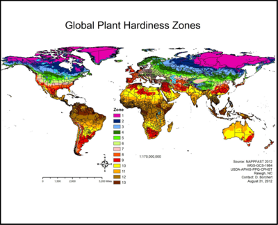
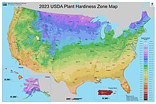
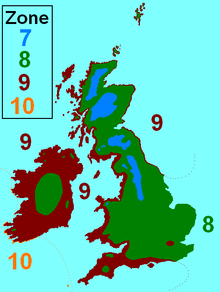
A hardiness zone is a geographic area defined as having a certain average annual minimum temperature, a factor relevant to the survival of many plants.The original and most widely used system, developed by the United States Department of Agriculture (USDA) as a rough guide for landscaping and gardening, defines 13 zones by long-term average annual extreme minimum temperatures.The low latitude and often stable weather in Florida, the Gulf Coast, and southern Arizona and California, are responsible for the rarity of episodes of severe cold relative to normal in those areas.The first attempts to create a geographical hardiness zone system were undertaken by two researchers at the Arnold Arboretum in Boston; the first was published in 1927 by Alfred Rehder,[1] and the second by Donald Wyman in 1938.It revised hardiness zones, reflecting generally warmer recent temperatures in many parts of the country, and appeared similar to the AHS 2003 draft.[7] Two new zones (12 and 13) were added to better define and improve information sharing on tropical and semitropical plants, they also appear on the maps of Hawaii and Puerto Rico.There is a very small spot east of San Juan, Puerto Rico, that includes the airport in coastal Carolina, where the mean minimum is 67 degrees F (19 C), which is classified as hardiness Zone 13b, the highest category, with temperatures rarely below 65 °F (18 °C).The map has a higher resolution than previous editions, and is able to show local variations due to factors such as elevation or large bodies of water.[11] In November 2023, the USDA released another updated version of their plant hardiness map, based on 1991–2020 weather data across the United States.Zone information alone is often not adequate for predicting winter survival, since factors such as frost dates and frequency of snow cover can vary widely between regions.As an extreme example, due to the Gulf Stream most of the United Kingdom is in zones 8–9, while in the US, zones 8–9 include regions such as the subtropical coastal areas of the southeastern US and Mojave and Chihuahuan inland deserts, thus an American gardener in such an area may only have to plan for several nights of cold temperatures per year, while their British counterpart may have to plan for several months.[citation needed] Many plants may survive in a locality but will not flower if the day length is insufficient or if they require vernalization (a particular duration of low temperature).There are many other climate parameters that a farmer, gardener, or landscaper may need to take into account as well, such as humidity, precipitation, storms, rainy-dry cycles or monsoons, and site considerations such as soil type, soil drainage and water retention, water table, tilt towards or away from the sun, natural or humanmade protection from excessive sun, snow, frost, and wind, etc.[34] In addition, the Köppen climate classification system can be used as a more general guide to growing conditions when considering large areas of the Earth's surface or attempting to make comparisons between different continents.The 1990 version of the USDA Plant Hardiness Zone Map included Canada and Mexico, but they were removed with the 2012 update to focus on the United States and Puerto Rico.[77] Owing to the moderating effect of the North Atlantic Current on the Irish and British temperate maritime climate, Britain, and Ireland even more so, have milder winters than their northerly position would otherwise afford.In Sweden and Finland generally, at sea level to 500 metres (1,600 ft), zone 3 is north of the Arctic Circle, including cities like Karesuando and Pajala.Another notable example is Waksmund, a small village in the Polish Carpathians, which regularly reaches −35 °C (−31 °F) during winter on calm nights when cold and heavy airmasses from the surrounding Gorce and Tatra Mountains descend down the slopes to this low-lying valley, creating extremes which can be up to 10 °C (18 °F) colder than nearby Nowy Targ or Białka Tatrzańska, which are both higher up in elevation.[80] The southern European marker plant for climate as well as cultural indicator is the olive tree, which cannot withstand long periods below freezing so its cultivation area matches the cool winter zone.In the Iberian Peninsula, it can be found on the southern coast, in small Spanish areas inside the provinces of Almería, Cádiz, Granada, Málaga and Murcia.

1
2
3
4
5
6
7
8
9
10
11
United States Department of AgricultureInternational Energy Conservation CodeRoyal Horticultural SocietyAmerican Horticultural SocietyAntarcticaAntarctic ice sheetHawaiiPuerto RicoAlaskaFloridaGulf CoastArizonaCalifornia48 contiguous statesFlorida KeysMinnesotaArnold ArboretumBostonAlfred RehderDonald WymanUS National ArboretumWashingtonurban heat islandsBaltimoreWashington, D.C.Atlantic City, New JerseyArbor Day FoundationSan JuanCarolinadigitallyZIP CodeAlbany, New YorkAlbuquerque, New MexicoAllentown, PennsylvaniaAmarillo, TexasAnchorage, AlaskaAsheville, North CarolinaAtlanta, GeorgiaAustin, TexasBakersfield, CaliforniaBaltimore, MarylandBirmingham, AlabamaBoise, IdahoBoston, MassachusettsBrownsville, TexasBuffalo, New YorkCharleston, South CarolinaCharleston, West VirginiaCharlotte, North CarolinaChicago, IllinoisCincinnati, OhioCleveland, OhioColorado Springs, ColoradoColumbus, OhioDallas, TexasDavenport, IowaDenver, ColoradoDes Moines, IowaDetroit, MichiganEl Paso, TexasErie, PennsylvaniaEureka, CaliforniaFairbanks, AlaskaFlagstaff, ArizonaFresno, CaliforniaGrand Rapids, MichiganGreensboro, North CarolinaGreenville, South CarolinaHarrisburg, PennsylvaniaHartford, ConnecticutHilton Head, South CarolinaHonolulu, HawaiiHouston, TexasIndianapolis, IndianaJacksonville, FloridaJuneau, AlaskaKansas City, MissouriKey WestKnoxville, TennesseeLas Vegas, NevadaLittle Rock, ArkansasLos Angeles, CaliforniaLouisville, KentuckyMadison, WisconsinMemphis, TennesseeMiami, FloridaMilwaukee, WisconsinMinneapolis, MinnesotaMobile, AlabamaNashville, TennesseeNew Haven, ConnecticutNew Orleans, LouisianaNew York, New YorkOklahoma City, OklahomaOmaha, NebraskaOrlando, FloridaPhiladelphia, PennsylvaniaPhoenix, ArizonaPittsburgh, PennsylvaniaPortland, MainePortland, OregonProvidence, Rhode IslandProvincetown, MassachusettsRaleigh, North CarolinaReno, NevadaRichmond, VirginiaRochester, New YorkSacramento, CaliforniaSalt Lake City, UtahSan Antonio, TexasSan Diego, CaliforniaSan Francisco, CaliforniaSan Jose, CaliforniaSan Juan, Puerto RicoSanta Fe, New MexicoScranton, PennsylvaniaSeattle, WashingtonSitka, AlaskaSpokane, WashingtonSt. George, UtahSt. Louis, MissouriSyracuse, New YorkTampa, FloridaTrenton, New JerseyTucson, ArizonaTulsa, Oklahoma