Getafe
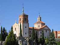
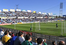
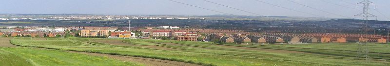
The Cerro de los Ángeles hill, a site traditionally considered to be the geographical center of the Iberian Peninsula, also lies within the municipal limits.In the 3rd century AD, the Romans constructed a villa called La Torecilla, whose ruins are still visible on the banks of the Manzanares River.The area was subsequently overrun by a series of Germanic tribes, including Suebi, Vandals and Visigoths, and the Indoeuropean Alans.In 1326, the inhabitants of the villages moved closer to the royal road connecting Madrid and Toledo, in effect creating a new settlement, Getafe.During the late Middle Ages, Getafe was a hamlet attached to the sexmo of Villaverde,[4] one of the rural subdivisions of the Land of Madrid.In 1763, King Charles III ordered the construction of a new road connecting Madrid to Aranjuez and, further on, to Cádiz, which passed along the foot of the Cerro de los Ángeles.King Alfonso XIII inaugurated the first monument to the Sacred Heart of Jesus on the Cerro de los Ángeles on 30 May 1919.The city was forced to create the neighborhoods of San Isidro, El Bercial, Juan de la Cierva, and Las Margaritas in the 1970s in order to support these new industries.The coat of arms of Getafe is divided vertically into two equal halves that represent the two most important characteristics of the municipal district.The right half contains a repeated pattern of airplanes representing the aeronautical tradition of the area and referencing the nearby Air Force Base.In 2011, Juan Soler-Espiauba Gallo, of the People's Party (PP), was elected mayor and displaced the incumbent, a socialist, who had held this post since 1983.The Getafe city council is divided into a number of different focus groups: treasury, wealth, and social security; equality; urbanism; civil action; and management of waste disposal, cleanliness, the environment, and the home.It is physically located in the centre of the Iberian Peninsula, north of the Southern Submeseta (part of the Meseta Central), in the Manzanares River basin.Due to its central location within the Iberian Peninsula, Getafe is no more than 725.6 km from any Spanish provincial capital in mainland Spain.The highest elevation is found on the extreme west, on Buenavista, a 704 m (2310 ft) hill which sits on the border between the municipalities of Getafe and Leganés, some 12 km South of Madrid.One of the major problems of Getafe's climate is air pollution, which increases noticeably when the wind blows South or Southeast.Native flowering plants include those of the genus Cistus and the common broom (Cytisus scoparius), though these species are not abundant.Most undeveloped land is devoted to the cultivation of cereals (mostly wheat), and, to a lesser extent, to gardens in the fertile lowlands of the Manzanares river.Common trees in the parks and streets of the city are the horse chestnut (Aesculus hippocastanum), the acacia, the elm (Ulmus minor), and the stone pine.The popular architectural style in Getafe is generally characterised by two-story buildings with tile roofs, various small balconies on the second floor, and a bare brick façade.Due to the developmental limitations imposed by the Air Force Base and the municipality borders, the city's parks and green spaces are important conservation areas.The parks cover an area approximately the size of Getafe Centro, and make up the western part of the urban centre, separated from the east by the A-42.A third project calls for the construction of a university, the Universidad Politécnica de Getafe, which will include three departments and a central building.Since the 1960s, a population boom prompted the creation of new neighbourhoods, such as those of San Isidro, Juan de la Cierva, Las Margaritas, and El Bercial.The importance of agriculture on the local economy has decreased significantly in the past century, though eastern parts of the municipality still include good plots of irrigated and nonirrigated land.A fair is held during these days on the fairgrounds, political parties set up stalls on the Calle Ferrocarril, and there are a number of cultural activities, including concerts and bull fights.Finally, the academic rector of the Universidad Carlos III is located in Getafe, along with three of its humanities and judicial science faculties.In anticipation of the local soccer team's rise to the first division, the public pool in Getafe Norte was expanded to include a training center.The Apanid, a residential facility specializing in the care of people with Down syndrome, is located on the Prado Acedinos (street), approximately 5 km south of the city center.[19] The Perales del Río neighborhood boasts the world's largest population of the common kestrel (Falco tinnunculus).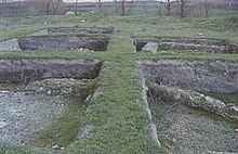


Getafe, BoholGetafe CFMunicipalityCountryRegionCommunity of MadridSara Hernández BarrosoDemonymTime zonePostal codeDialing codeMadridMeseta CentralManzanares RiverCerro de los ÁngelesIberian PeninsulaAirbusGetafe Air BaseSpanish militaryCharles III University of MadridMiddle AgesToledoLower Paleolithicstone toolsGermanic tribesVandalsVisigothsAlfonso VIAlonso de CovarrubiasDiocese of GetafeCharles IIIAranjuezCádizEngravingAlfonso XIIISacred HeartConstrucciones Aeronáuticas S.A.Juan de la CiervaautogyroJohn DeereSiemens AGLas MargaritasCanal de Isabel IIUniversidad Carlos IIILine 12coat of armsLatin crossSacred Heart of JesusSpanish Socialist Workers' PartyUnited LeftPodemosPeople's PartyPeoples' Partyred belt2007 Spanish regional electionsWorkers' CommissionsUnión General de Trabajadoresautonomous community of MadridPuerta del SolprovinceGironaLeganésFuenlabradaMediterranean SeaValenciaBay of BiscaySantanderAtlantic OceanPortugueseFrenchriver basinJaramaVillaverdeVallecasRivas VaciamadridSan Martín de la VegaRivas-Vaciamadridcold semi-aridKöppen climate classificationrelative humiditydroughtprecipitationsunshine hoursAgencia Estatal de Meteorologíamediterranean forestcork oaksCistuscommon broomstone pinesaleppo pineshorse chestnutacaciacedarscypresspoplarspalm treessparrowspigeonscommon kestrelbalconiesindustrial parkColiseum Alfonso Pérezautovía A-42Las Margaritas (Madrid)Conservatorio Profesional de Música de GetafeUniversidad Carlos III de MadridConstrucciones AeronáuiticasDefence and SpaceHelicoptersseating capacityCercanías MadridAutovíasAlcorcónMadrid Barajas International AirportSerranillosMadrid Metro systemMadrid Metro Line 12Instituto Nacional de EstadísticaLatin Americaeastern Europewestern EuropeSalamancaLogroñoTorrejón de ArdozSiemensConstrucciones Aeronáuticas SA