Gera
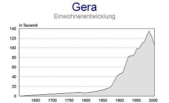
The city lies in the East Thuringian Hill Country, in the wide valley of the White Elster, between Greiz (upstream) and Leipzig (downstream).The small town got circumvallated in the 13th century on an area of 350 x 350 m and the Vogts' city castle was built in the south-western corner at today's Burgstraße.In 1450, Gera was almost totally destroyed during the Saxon Fratricidal War, but it could recuperate quick because the starting textile manufacture brought wealth to the town.In 1673, the Reussians were raised to Imperial Counts which granted them full sovereignty within the Holy Roman Empire; Gera became their royal residence.After the incorporation of some suburbs in the 1910s and 1920s Gera, with some 80,000 inhabitants, was the largest city in Thuringia, although the more centrally located Weimar became its capital.After the Nazi takeover of Germany, the Jewish community of Gera was destroyed, the synagogue burnt down in the Kristallnacht in 1938 and the city's Jews emigrated or were murdered in concentration camps.A month before the end of World War II, on 6 April 1945, U.S. bombing destroyed parts of the city and killed 514 residents.[5] Gera became part of the GDR in 1949 and was a flash point in the Uprising of 1953 in East Germany as thousands of workers – among them many employees of the Soviet-established Wismut uranium mining entity in the nearby Ore Mountains (Erzgebirge) – demanded higher wages and free elections.The population rose during the GDR period, and massive Plattenbau prefabricated apartment blocks, built throughout East Germany, were constructed in Gera.Gera is located in a smooth-hilly landscape in eastern Thuringia at the White Elster river (progression: Saale→ Elbe→ North Sea), between the Thuringian Highland approx.The elevation is between 180 metres (the level of the White Elster river) and 354 m (1,161.42 ft) (when measured at Gera-Falka at the furthest southeastern point).The city's topography creates a microclimate caused through the basin position with sometimes inversion in winter (quite cold nights under −20 °C (−4 °F)) and heat and inadequate air circulation in summer.Gera abuts the following municipalities: The 12 statistical districts are: The main urban quarters are the city centre, Untermhaus (incorporated 1919) in the west, Langenberg (1950), Tinz (1919) and Bieblach (1905) in the north, Leumnitz (1919) in the east, Pforten (1919) and Zwötzen (1919) in the south-east as well as Debschwitz (1912) and Lusan (1919) in the south-west.During the 1990s and the 2000s, many inhabitants left Gera to search a better life in west Germany or other major east German cities like Jena or Leipzig.Now, the birth deficit, caused by the high average age of the population, is getting a bigger problem because the immigration isn't sufficient to compensate it yet.Despite urban planning activities to tear down unused flats, vacancy is still a problem with rates around 12% (according to 2011 EU census).[11] The most important regions of origin of Gera migrants are bordering rural areas of Thuringia, Saxony-Anhalt and Saxony as well as foreign countries like Poland, Russia, Ukraine, Hungary, Serbia, Romania and Bulgaria.Like other eastern German cities, Gera has only a small foreign population: circa 1.6% are non-Germans by citizenship and overall 5.0% are migrants (according to 2011 EU census).During recent years, the economic situation of the city improved a bit: the unemployment rate declined from 22% in 2005 to 11% in 2013, which is still the highest one out of all Thuringian districts.In 2011, 9.8% were members of the Evangelical Church in Central Germany and 2.6% were Catholics, giving Gera one of the lowest shares of religious people in the Western world.The historic city centre is quite small and located between Sorge in the north, Nicolaistraße in the east, Stadtgraben in the south and Reichsstraße in the west.It survived World War II, but during the 1960s and 1970s, the GDR government demolished larger inner-city areas to rebuild them with modern concrete architecture, which marks the view of Gera's centre, particularly in the north-west until today.One important industrial branch had been uranium-ore mining in nearby Ronneburg (Wismut), whereby the region became the Soviet Union's leading uranium supplier.Today, there are regional express trains to Göttingen via Jena and Erfurt, to Leipzig via Zeitz, to Altenburg, Glauchau and Zwickau via the Gößnitz line, to Greiz, to Hof and to Saalfeld.


Gera (disambiguation)Gera Central StationWhite ElsterGermanyThuringiaDistrictUrban districtLord mayorTime zonePostal codesDialling codesVehicle registrationErfurtEisenachWeimarVogtlandPlauenLeipzigCentral German Metropolitan RegionDresdenHof (Saale)House of ReussPrincipality of Reuss-GeraPeople's State of Reussmicrostates the Thuringian region consisted ofGera administrative district (Bezirk)BundesgartenschauOtto DixOtto IIIQuedlinburg AbbeyReussiansWettinsSaxon Fratricidal WarReformationSchmalkaldic WarBohemian CrownSpanish NetherlandsCount Henry'sPutting-out systemImperial CountsHoly Roman EmpireNapoleonWar of the Fourth CoalitionFrederick William III of PrussiaPrussiaBattle of JenaSchleizPower loomWeißenfelsGerman Revolution of 1918–19Republic of ReussKristallnachtconcentration campsUprising of 1953 in East GermanyWismuturanium miningOre MountainsDistrict of GeraPlattenbauGerman reunificationNorth SeaThuringian HighlandLeipzig Bayabove sea levelhumid continental climateoceanic climateKöppen climate classificationinversionprecipitationrelative humiditysunshine hoursWorld Meteorological OrganizationBurgenlandkreisWetterzeubeGutenbornSaxony-AnhaltPölzigHirschfeldBrahmenauSchwaaraKorbußenRonneburgKauernHilbersdorfEndschützWünschendorfZedlitzHundhauptenKraftsdorfHartmannsdorfBad KöstritzSaale-HolzlandSilbitzSuburbanizationSaxony2011 EU censusRussiansVietnamese peopleUkrainiansEvangelical Church in Central GermanyAfghanistanRomaniaRussiaPolandBulgariaSomaliaTurkeyVietnamEritreaSerbiaCzech RepublicBauhausOtto LindigAenne Biermannbotanical gardenBotanischer Garten GeraHenry van de VeldeGründerzeitHeinrich SeelingDeutsche TelekomVEB Carl Zeiss JenaSoviet UnionCentral Place TheoryZwickauThuringian RailwayGößnitz