Geography of Ethiopia
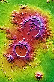
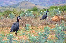
Narrow and deep clefts, through which descend mountain torrents that lose themselves in the sandy soil of the Eritrean coast, afford means of reaching the plateau, or the easier route through the Awash Valley may be chosen.The northern portion lies mainly between 10° and 15° N. It consists of a huge mass of Archaean rocks with a mean height of 2,000 to 2,200 m (6,562 to 7,218 ft) above sea level, and is flooded in a deep central depression by the waters of Lake Tana.One result of the action of the water has been the formation of numerous isolated flat-topped hills or small plateaus, known as ambas, with nearly perpendicular sides.The Semien Mountains lie northeast of Lake Tana and culminate in the snow-covered peak of Ras Dashen, which has an altitude of 4,550 m (14,928 ft).[4] The Bale Mountains are separated from the larger part of the Ethiopian highlands by the Great Rift Valley, one of the longest and most profound chasms in Ethiopia.Most of the Ethiopian uplands have a decided slope to the northwest, so that nearly all the large rivers flow in that direction to the Nile, comprising some 85% of its water.During the rains the Tekezé (i.e. the "Terrible") rises some 5 m (16.4 ft) above its normal level, and at this time forms an impassable barrier between the northern and central regions.[4] In Sudan, the Setit is joined (at 14°20′N 35°51′E / 14.333°N 35.850°E / 14.333; 35.850) by the Atbarah, a river formed by several streams which rise in the mountains west and northwest of Lake Tana.At the southeast corner the rim of the crater is, as it were, breached by a deep crevasse through which the Abay escapes, and here makes a great semicircular bend like that of the Tekezé, but in the reverse direction – east, south and north-west – down to the plains of Sennar, where it takes the name of Bahr-el-Azrak or Blue Nile.[4] In the mountains and plateaus of Gambela and Kaffa in southwestern Ethiopia rise the Baro, Gelo, Akobo and other chief affluents of the Sobat tributary of the Nile.It reaches the Afar Depression through a broad breach in the eastern escarpment of the plateau, beyond which it is joined on its left bank by its chief affluent, the Germama (Kasam), and then trends round in the direction of the Gulf of Tadjoura.This remarkable phenomenon is explained by the position of Lake Abbe in the centre of a saline lacustrine depression several hundred meters below sea level.While most of the other lagoons are highly saline, with thick incrustations of salt round their margins, Lake Abbe remains fresh throughout the year, owing to the great body of water discharged into it by the Awash.In this chain of scenic upland lakes – some fresh, some brackish, some completely closed, others connected by short channels – the chief links in their order from north to south are: Zway, communicating southwards with Hara and Lamina, all in the Arsi Zone; then Abijatta with an outlet to a smaller turn to the Baroda and Gamo areas, skirted on the west sides by grassy slopes and wooded ranges from 2,000 m (6,562 ft) to nearly 3,000 m (9,843 ft) high; lastly, Lake Chew Bahir (formerly known as Lake Stephanie) which is completely closed and falling to a level of about 550 m (1,804 ft) above sea level.[6] More recent work has focused on the Afar Depression, due to its importance as one of two places on Earth where a mid-ocean ridge can be studied on land (the other is Iceland).The upper (Magdala group) contains much trachytic rock of considerable thickness, lying perfectly horizontally, and giving rise to a series of terraced ridges characteristic of central Ethiopia.But the rainy season proper, caused by the southwest monsoon, lasts from June to mid-September, and commencing in the north moves southward.[6] The rainy season is of great importance not only to Ethiopia but to the countries of the Nile valley, as the prosperity of the eastern Sudan and Egypt is largely dependent upon the rainfall.In the valleys and lowlands the vegetation is dense, but the general appearance of the plateaus is of a comparatively bare country with trees and bushes thinly scattered over it.Among the many varieties of trees and plants found are the date palm, mimosa, wild olive, giant sycamores, junipers and laurels, the myrrh and other gum trees (gnarled and stunted, these flourish most on the eastern foothills), a magnificent pine (the Natal yellow pine, which resists the attacks of the white ant), the fig, orange, lime, pomegranate, peach, apricot, banana, and other fruit trees; the grape vine (rare), blackberry, and raspberry; the cotton and indigo plants, and occasionally the sugar cane.Large areas are covered by the kosso, a hardy member of the rose family, which grows from 2.5 to 3 m (8.2 to 9.8 ft) high and has abundant pendent red blossoms.The fruit of the hurarina, a tree found almost exclusively in Shoa, yields a black grain highly esteemed as a spice.The hippopotamus and crocodile inhabit the larger rivers flowing west, but are not found in the Hawash, in which, however, otters of large size are plentiful.[19] Leopards, both spotted and black, are numerous and often of great size; hyenas are found everywhere and are hardy and fierce; the lynx, African wolf, wild dog and jackal are also common.The giraffe is found in the western districts, the zebra and wild ass frequent the lower plateaus and the rocky hills of the north.[19] Among the varieties are the greater and lesser kudu (both rather rare); the duiker, gemsbok, hartebeest, gerenuk (the most common—it has long thin legs and a camel-like neck); klipspringer, found on the high plateaus as well as in the lower districts; and the dik-dik, the smallest of the antelopes, its weight rarely exceeding 5 kg (11 lb), common in the low countries and the foothills.Numerous eagles, vultures, hawks, bustards and other birds of prey live in Ethiopia, as well as partridges, guineafowl, sandgrouse, curlews, woodcock, snipe, pigeons, thrushes and swallows are very plentiful.


Addis ZemenSimien Mountains National ParkHawzenDallolcrater lakeBorana National ParkAbijatta-Shalla National ParkHorn of AfricaEritreaDjiboutiSomaliaSouth SudanEthiopiaEthiopian HighlandsRas DashenGreat Rift ValleyBlue NileLake TanaPuntlandGalmudugplateausplainsRed SeaRas Kasar18° NAnnesley Bay15° N40° EAwash RivermassifAhmar MountainsGulf of AdendepressionLake TurkanaDebub Omo ZoneSouthern Nations, Nationalities, and Peoples Region11° NEast Sudanian savannaAwash ValleyArchaeanfissureserosiveSemienTullu DemtuChilaloMount Abuna YosefMagdalaMisraq GojjamMount Choqa10° NEthiopian xeric grasslands and shrublandsList of rivers of EthiopiaHydrogeologyTekezé RiverendorheicTurkana BasinShebelle RiverAtbarah RiverJubba Riverdrainage basinKassalaSennarBashiloAmharaAddis AbabaDidessaDinderGambelaAfar DepressionGermamaGulf of TadjouraFlamingosLake AbbebrackishArsi ZoneAbijattaLake Chew BahirGanale Doriahot springsSodereGeology of EthiopiaErta AleAfar RegiontablelandW. T. Blanfordmid-ocean ridgeIcelandSedimentarymetamorphicalluviumTertiaryLimestonesHarrarJurassicAntalo LimestonesTriassicAdigrat SandstonesGneissesschistsIgneousAshangi groupFalse-colorMallahleSork AledefileAdigratAntalo groupAdigrat SandstoneKaroo SystemMassawaClimate of EthiopiaKöppen climate classificationequatorOromiaTekezémalariaSomali RegionDanakil DepressionalpineGojjamWelegaTigrayrelative humiditysunshine hoursWorld Meteorological OrganisationDeutscher Wetterdienst