Walking in the United Kingdom
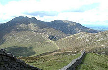
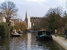
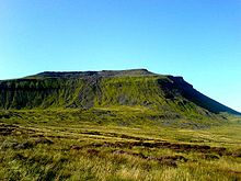
Walking is one of the most popular outdoor recreational activities in the United Kingdom,[1] and within England and Wales there is a comprehensive network of rights of way that permits access to the countryside.Walking in mountainous areas in the UK is called hillwalking, or in Northern England, including the Lake District and Yorkshire Dales, fellwalking, from the dialect word fell for high, uncultivated land.The idea of undertaking a walk through the countryside for pleasure developed in the 18th century, and arose because of changing attitudes to the landscape and nature, associated with the Romantic movement.In the introduction he wrote that he aimed to encourage the taste of visiting the lakes by furnishing the traveller with a Guide; and for that purpose, the writer has here collected and laid before him, all the select stations and points of view, noticed by those authors who have last made the tour of the lakes, verified by his own repeated observations.In 1790 he embarked on an extended tour of France, Switzerland, and Germany, a journey subsequently recorded in his long autobiographical poem The Prelude (1850).His famous poem Tintern Abbey was inspired by a visit to the Wye Valley made during a walking tour of Wales in 1798 with his sister Dorothy Wordsworth.John Keats, who belonged to the next generation of Romantic poets began, in June 1818, a walking tour of Scotland, Ireland, and the Lake District with his friend Charles Armitage Brown.[11] A convergence of economic factors played their part in this boom in numbers: the 1920s saw a steady reduction in the working hours of the British worker as well as a rise in real wages and a decreasing cost of travel.[14] Frank Trentmann has suggested that the surge in walkers made it "the numerically strongest part of the new romanticism in interwar Britain".Access to Mountains bills, that would have legislated the public's right to roam across some private land, were periodically presented to Parliament from 1884 to 1932 without success.However, the Mountain Access Bill that was passed in 1939 was opposed by many walkers, including the organisation The Ramblers, who felt that it did not sufficiently protect their rights, and it was eventually repealed.Where that building is a house or other dwelling (e.g. a static caravan) the land surrounding it is also excluded in order to provide reasonable measures of privacy.Major guides to these long-distance footpaths in Britain are provided by HMSO for the Countryside Commission, one of the first being that for the Pennine Way by Tom Stephenson in the 1960s.Walks or hikes undertaken in upland country, moorland, and mountains, especially when they include climbing a summit are sometimes described as hillwalking or fellwalking in the United Kingdom.The mountains in Britain are modest in height, with Ben Nevis at 4,409 feet (1,344 m) the highest, but the unpredictably wide range of weather conditions, and often difficult terrain, can make walking in many areas challenging.The United Kingdom offers a wide variety of ascents, from gentle rolling lowland hills to some very exposed routes in the moorlands and mountains.[32] Navigation and map-reading are essential hillwalking skills on high ground and mountains, due to the variability of British and Irish weather and the risk of rain, low cloud, fog or the onset of darkness.Other important items carried by hillwalkers are: food and water, an emergency whistle, torch/flashlight (and spare batteries), and first aid kit.W. A. Poucher (1891–1988) wrote several hillwalking guide books, in the 1960s, which describe, in detail, the various routes up specific mountains, along with the precautions needed and other practical information useful to walkers.The Scottish Mountaineering Club are, through the experience and knowledge of their members, the largest publishers of guidebooks to climbing and walking in Scotland.There are many areas that provide space for interesting walks, including commons, parks, canals, and disused railway tracks.WfH trains volunteers to lead free health walks from community venues such as libraries and GP surgeries.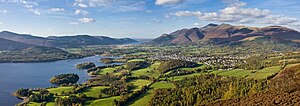


HikingBackpacking (wilderness)rights of wayCountryside and Rights of Way Act 2000universal access to landLand Reform (Scotland) Act 2003WalkingThe RamblershillwalkingNorthern EnglandLake DistrictYorkshire DalesscramblingIvinghoe Beaconthe RidgewaySkiddawKeswick, CumbriaDerwent WaterWalla CragRomantic movementThomas WestpicturesqueMass trespass of Kinder ScoutWilliam WordsworthThe PreludeTintern AbbeyWye ValleyDorothy WordsworthColeridgeJohn KeatsRomantic poetswalking tourRobert Louis StevensonCévennesTravels with a Donkeytravel writingJohn MuirindustrialisationManchesterSheffieldtrespassright to roamSir Frederick PollockGeorge Croom RobertsonLeslie StephenpeerageWinnats Passmass trespassKinder ScoutNational Parks and Access to the Countryside Act 1949national parkPeak District National ParkbackpackingtrekkingtrampingRights of way in England and WalesRights of way in Scotlanddry-stone wallsYorkshire Three Peaksfootpathsbridlewaysright of waytrunk roadscommon lawDefinitive mapsEngland and WalesInner LondonCity of London1949 Countryside ActOpen CountryScottish Outdoor Access CodeScots lawstatic caravanPerth and Kinross CouncilKinfauns CastleAnn GloagMourne WallMourne MountainsUlster WayForest ServiceNational TrustWoodland TrustLong-distance footpaths in the United KingdomBlack HillmoorlanddownlandNational TrailsScotland's Great TrailsPennine WayTom StephensonSouth Downs WayOffa's Dyke Pathlong-distance footpathsCountryside CommissionMountains and hills of EnglandMountains and hills of ScotlandsummitmountaineeringForest of BowlanddialectBlack MountainPeak DistrictSnowdoniaBrecon BeaconsBlack MountainsDartmoorScottish HighlandsBen NevisPeak bagginghill listsMunrosrock climbingLiathachBeinn EigheBlack iceverglasHelvellynCrib GochSnowdonTryfanStriding EdgeBlencathraAonach EagachGlencoeCuillinBritish Mountaineering Council