Districts of Yerevan
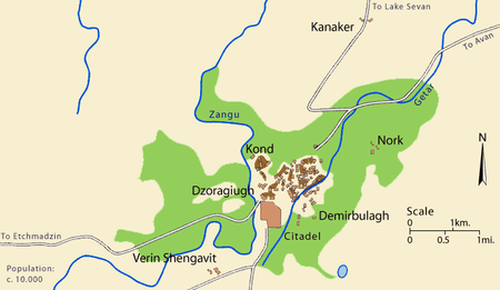
[2][3][4][5] Since the 17th century, without the fortress and nearby villages (Noragyugh, Dzoragyugh and Nork), Yerevan was divided into three main quarters (mahlas; Persian: محله): The market (Ghantar) was separate, between Kond and Shahar.First time it was mentioned as old Yerevan or the old city of Yerevan by bishop Pilipos of Bjni in 1631:[7][8] …after many searches I found it [the Bible] in the old city of Yerevan…Բազում որոնմամբ խուզեալ գտաք, զգանձս զայս անգին ի հին քաղաքն Երեւան բազում ժամանակաւ գերի տարեալ ումեք իբրեւ եօթանասնօքKond (Armenian: Կոնդ), so-named because of its high position.According to Hovhannes Shahkhatunyants, an Armenian historian, Kond located in the western and southern hillsides and foot of a rocky hill with similar name.[10][11] Demir-Bulagh become crowded in the 17th century, when terrified of the Persian invasions, many Turks from Nakhichevan moved to the areas north to the Yerevan Fortress.Ghantar (Armenian: Ղանթար, meaning "big scales in a marketplace", from Arabic: قنطار, qinṭār) was the active and business center of Yerevan.Dzoragyugh was called Khnkadzor or Khnkelo, because it was Yerevan's bishop's seat, the word "khunk" means 'incense' in Armenian.Dzoragyugh had three smaller neighborhoods: Nork (Armenian: Նորք, Turkish: Çömlekçi, meaning "potter") was the second villages near Yerevan, that became its part in the 1830s.Nor tagh (Armenian: Նոր թաղ, meaning “new district”) located in the eastern part of Kond, in the surrounding are of the Hovhannes Tumanyan House-Museum.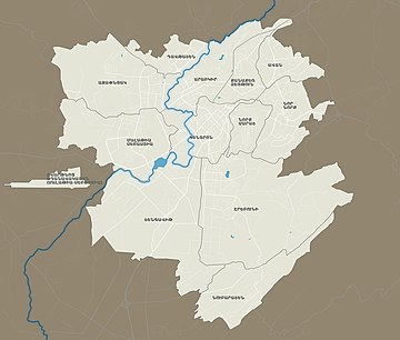


YerevanArmeniaAjapnyakArabkirDavtashenErebuniKanaker-ZeytunKentronMalatia-SebastiaNork-MarashNor NorkNubarashenShengavitfortressPersianUrartian timesArmenianTurkishHrazdan RiverbasaltArabicSurb Sargis ChurchEastern ArmeniaSimeon I of YerevanHrazdanSt. Sargis church1828 Treaty of TurkmenchayHistory of YerevanErebuni FortressArmenian OblastErivan GovernorateKhanate of ErevanHistory of ArmeniaHandes AmsoryaWayback Machine