Danco Coast
This coast was explored in January and February 1898 by the Belgian Antarctic Expedition under Adrien de Gerlache, who named it for Lieutenant Emile Danco who died on the expedition.[1] The coast is bordered by the Aguirre Passage which separates it from Lemaire Island.[2] The Danco Coast Tectonic Block includes the Upper Permian-Triassic Trinity Peninsula Group, consisting of over 1000 m of metaturbidites folded during the Gondwanide orogeny.These two groups were intruded by the Berriasian-Cenomanian granite and gabbro sills of the Andean Instrusive Suite.A system of hypabbysal dykes intruded during the Late Cretaceous or Tertiary.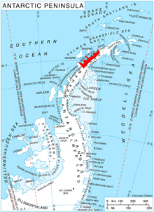

Antarctic PeninsulaCape SterneckCape RenardBelgian Antarctic ExpeditionAdrien de GerlacheAguirre PassageLemaire IslandBrabazon PointSalvesen CoveTectonic BlockUpper PermianTriassicfoldedGondwanide orogenyLower CretaceousVolcanicbasalticandesiticagglomeratesfaultedTertiaryintrudedBerriasianCenomaniangranitegabbrohypabbysalLate CretaceousMount FrödinGeographic Names Information SystemUnited States Geological SurveyGraham LandTrinity PeninsulaCape KjellmanDavis CoastGraham CoastCape BellueLoubet CoastBourgeois FjordFallières CoastCape JeremyPalmer LandRymill CoastButtress NunataksEnglish CoastEklund IslandsEllsworth LandRydberg PeninsulaCape LongingNordenskjöld CoastCape FairweatherOscar II CoastCape AlexanderFoyn CoastCape NorthropBowman CoastCape AgassizWilkins CoastCape BoggsBlack CoastCape MackintoshLassiter CoastCape AdamsOrville CoastCape ZumbergeZumberge CoastHercules InletLaclavère PlateauLouis Philippe PlateauDetroit PlateauHerbert PlateauFoster PlateauForbidden PlateauBruce PlateauAvery PlateauHemimont PlateauDyer Plateau