Core-based statistical area
[1] On July 15, 2015, the OMB released new standards based on the 2010 census.[2][3][4] These standards are used to replace the definitions of metropolitan areas from the 2010 United States census data.Micropolitan areas are based on Census Bureau-defined urban clusters of at least 10,000 and fewer than 50,000 people.Any combination of metro and micro areas may be used to form a CSA.Previously, these were referred to by the Census Bureau as New England county metropolitan areas (NECMA) and were separate from the normal census counts for the areas, based on cities and towns.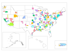
List of core-based statistical areascombined statistical areasUnited StatesOffice of Management and Budget2010 censusmetropolitan areasNew England city and town areasPuerto Ricometropolitan statistical areasmicropolitan statistical areasmicropolitan areasNew Englandcities and townsOutline of the United StatesIndex of United States-related articlesDemographics of the United StatesUnited States Census BureauList of U.S. states and territories by populationList of metropolitan areas of the United StatesList of United States cities by populationList of United States counties and county-equivalentsUnited States Office of Management and BudgetStatistical area (United States)Combined statistical areaMetropolitan statistical areaMicropolitan statistical areaNational ArchivesFrey, William H.Brookings InstitutionUnited States censusDivisionFederal DistrictInsular areaAmerican SamoaNorthern Mariana IslandsUnited States Virgin IslandsZIP Code Tabulation AreaAlaska Native corporationIndian colonyIndian reservationHawaiian home landOff-reservation trust landOklahoma Tribal Statistical AreaPrimary statistical areaNew England city and town areaUrban areaCongressional districtCountyAlaska census areaIndependent cityMunicipioCensus-designatedPublic use microdata areaSchool districtState legislative districtUrban growth areaCensus county divisionMinor civil divisionTraffic analysis zoneVoting districtBlock groupCensus Bureau