Conditional symmetric instability
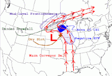
The instability in this case develop only in an inclined plane with respect to the two axes mentioned and that is why it can give rise to a so-called "slantwise convection" if the air parcel is almost saturated and moved laterally and vertically in a CSI area.An air particle at a certain altitude will be stable if its adiabatically modified temperature during an ascent is equal to or cooler than the environment.In the diagram on the right, the yellow line represents a raised particle whose temperature remains at first under that of the environment (stable air) which entails no convection.A measure of hydrostatic stability is to record the variation with the vertical of the equivalent potential temperature (As the absolute vortex is almost always positive on the synoptic scale, one can consider that the atmosphere is generally stable for lateral movement.can be satisfied only on the anticyclonic side of a strong maximum of jet stream or in a barometric ridge at altitude, where the derivative velocities in the direction of displacement in the equation give a significant negative value.[5] The variation of the angular momentum indicate the stability:[3][5][6] Under certain stable hydrostatic and inertial conditions, slantwise displacement may, however, be unstable when the particle changes air mass or wind regime.[5][6] Vertical movements in this case result in negative buoyancy as the particle encounters warmer air (The ideal situation is a geostrophic flow from the South with wind speeds that increase with height.This type of flow is typically found in baroclinic atmospheres with cold air to the west.[6] The image to the right shows such a situation in winter with CSI associated with negative equivalent potential vorticity (If a particle is climbing in a CSI zone, it will cool down and the water vapor will condense upon saturation, giving cloud and precipitation by oblique convection.[6][7] Conditional symmetric instability affects a layer that can be thin or very large in the vertical, similar to hydrostatic convection.The thickness of the layer determines the enhancement of convective precipitation within a region otherwise stratiform clouds.[6] As the motion is in an area near saturation, the particle remains very close to the moist adiabatic lapse rate which gives it a limited Convective available potential energy (CAPE).[6] It is however possible in:[6] Slantwise convection bands have several characteristics:[6] Conversely, if the particle slide downward, it will warm up and become relatively less saturated, dissipating clouds.The snow produced at higher altitude by the slantwise convection will also sublimate in the descending flow and accelerate.


Weather radarwarm frontconvective instabilityframe of referenceprecipitation bandsLapse ratetemperaturedew pointSkew-T log-P diagramequivalent potential temperaturegeostrophicCoriolis parametersynoptic scalejet streambarometric ridgeangular momentumbuoyancypotential vorticityprecipitationConvective available potential energycumulonimbuslightningmesoscale convective systemstropopauseeyewallthermal windsublimateSting jetAmerican Meteorological SocietyCharles A. Doswell IIIMétéo-FranceMonthly Weather ReviewNational Weather ServiceNational Severe Storms LaboratoryAdiabatic processesAdvectionSurface solar radiationSurface weather analysisVisibilityVorticityWind shearCondensationCloud condensation nuclei (CCN)Convective condensation level (CCL)Lifting condensation level (LCL)Precipitable waterWater vaporConvectionConvective available potential energy (CAPE)Convective inhibition (CIN)Convective momentum transportConvective temperature (Tc)Equilibrium level (EL)Free convective layer (FCL)K IndexLevel of free convection (LFC)Lifted index (LI)Maximum parcel level (MPL)Bulk Richardson number (BRN)Dew point (Td)Dew point depressionDry-bulb temperatureEquivalent temperature (Te)Forest fire weather indexHaines IndexHeat indexHumidexHumidityRelative humidity (RH)Mixing ratioPotential temperature (θ)Equivalent potential temperature (θe)Sea surface temperature (SST)Temperature anomalyThermodynamic temperatureVapor pressureVirtual temperatureWet-bulb temperatureWet-bulb globe temperatureWet-bulb potential temperatureWind chillPressureAtmospheric pressureBaroclinityBarotropicityPressure gradientPressure-gradient force (PGF)VelocityMaximum potential intensity