Chandeleur Islands
[1] The islands were named when the explorer Pierre Le Moyne d'Iberville was sailing in search of the mouth of the Mississippi River along the Gulf Coast.The Chandeleur Island Light, built in 1895, stood as a landmark and recognizable location for mariners at sea and pilots flying over the Gulf of Mexico.A study released in 2006 by geologists from the University of New Orleans shows that the usual sand and sediment patterns that rebuilt the islands after big storms have not been restored since Katrina reworked the area.There is also evidence of unprecedented landslides on the seafloor on the side toward the Gulf of Mexico, potentially allowing stronger waves with greater erosional impact to reach the islands.[citation needed] Boston dot com article 2006 is a dead link, internet archive data: https://web.archive.org/web/20070704010017/http://www.boston.com/news/science/articles/2006/08/02/chandeleur_islands_said_not_rebuilding/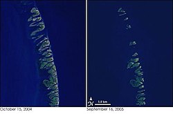


Frenchbarrier islandsGulf of MexicoChandeleur SoundLouisianaBreton National Wildlife RefugeMississippi RiverPierre Le Moyne d'IbervilleFête de la ChandeleurNational Wildlife RefugeChandeleur Island Lightwave actionstorm surgeshurricanesHurricane GeorgesHurricane KatrinaHurricane DennisshoalsgeologistsUniversity of New Orleanssea level riseDeepwater Horizon oil spillWayback MachineNASA Earth Observatory