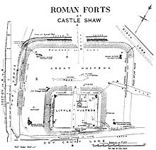
Castleshaw Roman Fort
The road crosses the Pennines at Standedge where the area dips and narrows, creating a traversable pass which would have been guarded by the Castleshaw fort.[5] There was also a small Roman military installation, possibly a fortlet or signal station at Worlow, between Slack and Castleshaw.[4] The fort at Castleshaw, constructed from turf and timber, was built around AD 79 and guarded the York to Chester Roman road.[7] The location of the fort's granary, stables, the principia (headquarters), the praetorium (commander's tent), and six long narrow buildings which are possibly workshops or storerooms are all known.[7] There were two construction phases of the fortlet, the second – dating to c. 120 – featured gates, an oven, a well, a granary, a hypocaust a workshop, barracks, a commanders house, a courtyard building, and possibly a latrine.[14] Stamps on two tegulae, produced at the Roman tilery at Grimescar Wood near Huddersfield, suggest the fortlet was supplied by the Cohors III Bracaraugustanorum from Pannonia, maybe even garrisoned by them at one stage.The remains were in good enough condition for him to draw a plan and he commented that he was "pleased to find a double Roman camp".[18] The spoil heaps from the 1907–08 dig were never levelled, leaving a series of misleading modern earthworks on the interior of the site.In an attempt to make the site accessible to the public, the outline of the fort and fortlet was marked out in low mounds and an education centre was set up nearby.[19] It has been possible, however, to ascertain that barrack buildings lay on the east side of the fort, a granary on the north, and the principia and praetorium to the south west.

CastleshawSaddleworthGreater ManchesterEnglandCoordinatescastellumRoman provinceBritanniaBrigantianStandedgeantiquarianarchaeologicalscheduled monumentarchaeological siteGrindslow shalePenninenorthern EnglandDeva VictrixChesterEboracumRoman roadMamuciumManchestergrid referencephasespraetoriumauxiliarycohortslightedhypocaustRoman armyPtolemyBrigantestegulaeHuddersfieldPannoniaEbchesterThomas PercivalAmmon Wrigleyexcavationspoil heapsUniversity of ManchesterBarri JonesRoman BritainNorth West WaterrampartpostholeScheduled Monuments in Greater ManchesterHistoric EnglandUniversity of Manchester Archaeological Unit