River Calder, West Yorkshire
[4] The river rises approximately 1,300 feet (400 m) above sea level at Heald Moor,[5] north-west of Todmorden, and drains an area of 369 square miles (957 km2).The river formed an important transportation system for raw materials and the products of the mills, particularly prior to the development of other infrastructures such as road and railway links to the area.Wakefield's medieval nine-arched bridge is 320 feet (98 m) long, was built in sandstone between 1342 and 1356, and replaced an earlier wooden structure on the site of an ancient ford.At Wakefield, a variety of former mill buildings are currently being redeveloped to create a Waterfront project which will combine residential housing, offices, galleries and public spaces.Around Huddersfield, Mirfield and Wakefield are popular areas for coarse fishing, roach, perch, chub, dace, minnows, gudgeon, pike, bream and trout.The areas upstream of Dewsbury are quickly becoming cleaner and more suited to game and specialised river cyprinids like barbel, as well as general coarse fish that are also doing well.As the river reached Huddersfield, the traditional textile industries created a considerable amount of water pollution, particularly through the processes involved in the production of synthetic dyes and in scouring the wool clean.The enormous growth of the population over the last hundred years (currently over 800,000 people live within the river's catchment) has caused other problems in relation to sewage.The river has a history of flooding, mainly due to the high sides of its banks in its earlier stages, which cause rapid runoff of water following heavy rain.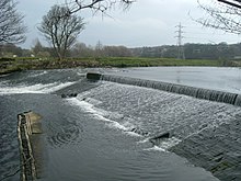
Calder Valley (UK Parliament constituency)EnglandWest YorkshireTodmordenHebden BridgeSowerby BridgeEllandBrighouseMirfieldDewsburyWakefieldHolme ChapelCornholmeLancashireRiver AireCastlefordNorthern Englandanother river with the same nameCalderdaleHalifaxKirkleesHebble BrookRiver ColneCalder and Hebble Navigationinland waterwayBrythonic languageModern WelshCalderstonesLiverpoolEast CalderWest CalderEdinburghCalderwoodGlasgowClan CalderWalsden*WalhazOld WelshEastwoodMytholmroydLuddendenfootCopleyHorbury BridgeCarboniferousMillstone GritreservoirsHebden WaterRochdaleGreater ManchesterPenninesRochdale CanalAire and Calder NavigationHumber EstuaryNorth SeaHeavy Woollen DistrictHuddersfieldUpper Calder Valleytextilerailwaymedievalsandstonechantry chapelThe Hepworth WakefieldWakefield KirkgateNormantonKirkthorpeHappy ValleyJamaica InnRemember MeBlack WorkJerichoThe Gallows PoleHeptonstallsalmonminnowsgudgeoncyprinidsbarbelSites of Special Scientific Interestkingfisherminingsoil erosionsewageYorkshire WaterurbanisedPugneys Country ParkcanoeingwaterskiinganglingIndustrial RevolutionPennine WayCalderdale WayRivers of the United KingdomList of crossings of the River Calder, West YorkshireList of most-polluted riversMurder of Lindsay RimerAike BeckArram BeckDerwentDriffield BeckFoulnessGypsey RaceHedon HavenHumberLambwath StreamPocklington BeckTrent FallsWest BeckWinestead DrainArkle BeckBedale BeckBishop DikeCock BeckCod BeckCosta BeckCrimple BeckEller BeckGreta (Lune)HertfordHodge BeckHolgate BeckMalham BeckOak BeckPickering BeckRamsdale BeckRibble