Blackwood River
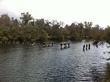
It travels in a southwesterly direction through Bridgetown then through Nannup until it discharges into the Southern Ocean at Hardy Inlet near the town of Augusta.[1] The river has a total catchment area of 28,100 square kilometres (10,849 sq mi) stretching from Kukerin in the east to Hardy Inlet in the west,[3] and from Darkan in the north to Augusta in the south.[5] Several major towns are found within the catchment including Katanning, Narrogin, Bridgetown, Boyup Brook and Nannup.[6] In 1827, Captain James Stirling, RN, arrived at the river and named it after Vice-Admiral Sir Henry Blackwood, under whom he served as a midshipman on HMS Warspite in 1808–1809 during the Napoleonic Wars, in the North Sea and the Mediterranean.In 1945 it rose to the highest level recorded to that date, running 1.1 metres (3.6 ft) over the Russell Street bridge in Nannup.


Arthur RiverBalgarup RiverHardy InletAugustaNannupBridgetownSouthern OceanBoyup BrookKukerinDarkanKatanningNarroginBlackwood PlateauWhicher ScarpScott Coastal PlainFlinders BayTowerrining Lake and Moodiarrup SwampAboriginal AustraliansBibulmanNoongarCaptainJames StirlingVice-AdmiralSir Henry BlackwoodmidshipmanHMS WarspiteNapoleonic WarsSwan River ColonyToolibin LakeRamsarBusseltontropical cycloneThe West AustralianKalgoorlie MinerThe MercuryThe Australian Women's WeeklyWestern AustraliaGascoyneEdmundFrederickLandorMinilyaThomasWooramelGoldfields–EsperanceAlexanderDalyupJerdacuttupMunglinupOldfieldPhillipsSteereGreat SouthernAngoveBremerDenmarkFitzgeraldFranklandGairdner (Great Southern)GoodgaGordonHamersleyKalganKing (Great Southern)PallinupShannonWalpoleWaychinicupKimberleyAdcockArmandaBarkerBarnettBartonBerckelmanBerkeleyBow (Kimberley)CalderCarsonChamberlainCharnleyDrysdaleDunhamDurackElvireErnestFitzroyForrestFraserGairdner (Kimberley)GlenelgHunterIsdellJohnstonKing (Kimberley)King EdwardKing GeorgeLennardMargaret (Kimberley)MitchellNicholsonPantonPentecostPrince RegentRichendaRobinsonWilsonMid WestArrowsmithBullerChapmanGreenoughMurchisonYalgarBennettCanningDandalupHarveyHelenaHothamMurraySerpentineSouth DandalupWilliamsClaisePilbara