Base end station
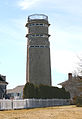
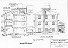
In general, however, a fire control tower (FCT) was a structure built to raise one or more base end, spotting, or observation stations high above ground level.Other base end stations resembled pillboxes or small bunkers dug into the ground or on the surface overlooking coastal waters.Almost all base end stations were equipped at least with an azimuth telescope (similar to a surveyor's theodolite) to enable them to sight accurate bearings to a target.This meant that a second spotting instrument (usually an azimuth telescope) on a separate pedestal (or tripod) was included in the observing room, alongside the primary one (which was usually a depression position finder [DPF]).In harbor defense plans and other documents, such as survey data sheets prepared by the United States Coast and Geodetic Survey (USC&GS) and maintained by its successors,[4] these combined stations were often labeled according to the tactical numbers[note 7] of the gun batteries they were designed primarily to serve and their number in the series of stations serving that battery.These systems used instruments such as the depression position finder (DPF) or the coincidence rangefinder (CRF) to measure the range and/or azimuth to the target.


United States Army Coast Artillery Corpsfire control systemsposition finding celltriangulationplotting roomplotting boardfire control towers (FCTs)azimuththeodolitedepression position finderWorld War IIUnited States Coast and Geodetic Surveycoincidence rangefinderFort AndrewsFire control towerFire-control systemSeacoast defense in the United StatesHarbor Defense CommandList of U.S. Army fire control and sighting material by supply catalog designationGun Data ComputerpintleCorrected firing dataplotting boards