2017 Washington wildfires
[3] On the morning of August 1, smoke from BC fires pushed into the Seattle area, rapidly making Mount Rainier invisible on a cloudless day.[7] The first measurable rainfall at Seattle-Tacoma International Airport (Sea-Tac) was 0.02 inches in mid-August, setting a record 55 day dry streak.[1][9] On September 5, ash from the Central Washington fires fell "like snow" on Seattle and as far west as Grays Harbor County which borders the Pacific Ocean.[10][11][12] University of Washington meteorology professor Cliff Mass said the situation in Seattle with "a smoke cloud so dense one would think it is low stratus deck" was unprecedented in his 30 years of experience.[31][32] On August 29, the Washington Military Department's Emergency Operation Center at Camp Murray was activated in response to the Jolly Mountain Fire.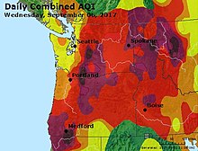


Diamond Creek FireJolly Mountain FirewildfiresWestern WashingtonEastern WashingtonWashington National GuardhelitackSeattle-Tacoma International AirportJay InsleeGrays Harbor CountystratusNewport, WashingtonEllensburg School DistrictUniversity of Idahohuman causesPasayten WildernessManning Provincial ParkColville National ForestMonument Hill2017 British Columbia wildfiresChinook PassEagle Creek FireColumbia GorgeSkamania Countyinfrared thermographyWashington Air National GuardFairchild Air Force BaseWashington Military DepartmentCamp MurrayOregon Public BroadcastingKING-TVKOMO-TVAlaska Dispatch NewsKCPQ-TVKREM-TVThe InlanderGlobal News MorningKAPP-TVKVAL-TV2017 wildfire seasonKnysna firesBearskin Fire2017 Arizona wildfiresHighline Fire2017 California wildfires2017 Montana wildfires2017 Oregon wildfiresUtah's Tank Hollow Fire2017 Chile wildfiresSoutheast Asian hazeJune 2017 Portugal wildfiresOctober 2017 Iberian wildfiresWildfires in GaliciaAustralia (16-17)2017 Port Hills fires◀ 20162018 ▶Washington wildfiresYacolt BurnGreat FireDollar MountainWhite MountainMount LeonaThirtymileSchoolTripod ComplexTatooshCold SpringsCarlton ComplexOkanogan ComplexRange 12Diamond CreekJack Creek FireUno Peak FireSoap LakeMaple Fire243 Command FireLeft Hand FireEvans CanyonLabor DaySchneider Springs FireEagle Bluff FireGray FireOregon FireNewell Road FireSourdough FireTunnel Five FirePioneer FireRetreat FireSwawilla Fire