2012 North American heat wave
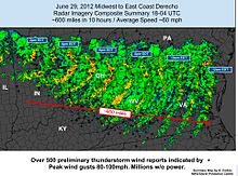
[7][8] The heat wave formed when high pressure aloft over the Baja California, Mexico, strengthened and moved over the southern plains around June 20–23 and then spread east and northward, remaining fixed over the center of North America through July 2012.[12][13] A NASA-sponsored study[14] indicates an increase in the drying tendency from spring to summer over the U.S. Central Plains, especially during the transition from June to July.The intensified deficit in precipitation is accompanied by increased downward shortwave radiation flux, tropospheric subsidence, enhanced evaporative fraction, and elevated planetary boundary layer height, all of which can lead to surface drying.The intense heat wave in the West was initiated around June 20–23 when the high pressure system centered over the Baja of California shifted upward into the plains[16] and caused temperatures to approach or even surpass 110 °F (43 °C) for the next several days, breaking many records for the area.[citation needed] The heat spread east from the Rocky Mountains and a massive high-pressure system over the Midwest caused extreme temperatures not seen on such a scale since the 1930s.[citation needed] In Bowling Green, Kentucky, the same day witnessed 109 °F (42.8 °C), one degree Fahrenheit (0.6 °C) short of the state's all-time record for June.The high pressure ridge continued to slide eastward and centered itself over Tennessee, causing hundreds of records to be matched or surpassed for multiple states, including Illinois, Indiana, Kentucky, Georgia, North Carolina, and Washington, D.C., among others.[citation needed] The scorching heat continued on June 29 when Athens, Georgia, and Columbia, South Carolina, set new all-time record high temperatures of 113 °F (45 °C).Normally, the highest temperature recorded in a typical Chicago summer is around 95 °F (35 °C), a streak of 3 days above 90 °F (32 °C) constitutes a "heat wave", and the thermometer reaches or surpasses 100 °F (38 °C) only once every five to ten years.Similarly, on July 7, daily record highs were broken in several cities in eastern Pennsylvania, including Harrisburg, Lancaster, and Chambersburg, which each reached 101 °F (38.3 °C).A major jet stream dip and associated upper-level trough of low pressure brought rain, storms, and cooler weather to parts of the eastern and central US, slightly lessening drought impacts in some areas.[12] The heat wave also contributed to the record-shattering 2012 North American drought, which caused massive crop failures throughout the Midwest.[44] On June 29–30, 2012, the heat and humidity from the heat wave caused a small thunderstorm in Iowa to develop into a violent and unprecedented derecho, which tracked across the Midwest and Mid-Atlantic regions of the United States while causing 80 miles per hour (130 km/h) or higher winds, doing hundreds of millions of dollars in damage, and downing trees and power lines, leaving four million people in the eastern U. S. without power.
March 2012 North American heat waveheat wavesUnited StatesCanadaJune 2012 North American derechoMountain StatesSouthwestern United StatesSouthern PlainsSouthwestern North American megadroughtBaja CaliforniaMexicoplanetary boundary layerRocky Mountainshigh-pressure systemDenver, ColoradoKansasAlamosa, ColoradoGalveston, TexasHill City, KansasFort Wayne, IndianaIndianapolisSt. Louis, MissouriLittle Rock, ArkansasBradley CountyTennesseehyperthermiaPaducah, KentuckyBowling Green, KentuckyNashvilleKnoxvilleChattanoogaNational Weather ServiceSmyrna, TennesseeFort Good Hope, Northwest TerritoriesTorontoIllinoisIndianaKentuckyGeorgiaNorth CarolinaWashington, D.C.Athens, GeorgiaColumbia, South CarolinaCharlotte, North CarolinaRaleigh, North CarolinaAtlanta, GeorgiaSouth CarolinaMid-Atlantic StatesSalisbury, MarylandBaltimoreO'Hare International Airport4th of JulyvillagesPark RidgeNorridgeCaledonia, WisconsinMilwaukeeAllegan, MichiganChicago1995 Chicago heat waveCook Countytrain derailmentRock CountyWisconsinCumberland, MarylandBremo Bluff, VirginiaNortheastern United Statesheat waveLaurel Mountain, PennsylvaniaJohnstownHarrisburgLancasterChambersburgPittsburghPierre, South DakotaDetroitMichiganOntarioAtlantic City, New JerseyNewark, New JerseyTeterboro AirportPhiladelphiaHartford, ConnecticutContiguous USjet streamtroughdrought impactsWaldo Canyon fire2012 North American droughtDust BowlSummer heat wave of 2012 derecho seriesderechoHeat DomeYahoo! NewsChicago TribuneThe Wall Street JournalNew ScientistWayback MachineAccuweatherThe Kansas City StarBeloit Daily NewsWUSA (TV)Newsday.comScientific AmericanThe New York TimesBusinessWeek2002 (India)2013 hazePakistan2016 (India)2017 (Pakistan)2018 (Northeast Asia)2019 (India and Pakistan)2022 (China)2022 (India and Pakistan)2022 (Japan)Mecca, Saudi Arabia (Hajj)Southeast AsiaList of Indian heat wavesJuly 17571906 (UK)1911 (UK)1955 (UK)UK and Ireland1990 (UK)1995 (UK)